

EarthQuake Tracker screenshots (6)



Description EarthQuake Tracker
Want to know if the ground beneath you is stable? EarthQuake Tracker provides real-time seismic monitoring and detailed hazard maps, putting global geological activity directly on your device.
Core Monitoring & Alert Features
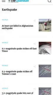
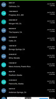
This application functions as a comprehensive seismic observation tool. It aggregates data from multiple international geological survey networks to display earthquake occurrences worldwide. The map interface visualizes event epicenters with color-coded markers indicating magnitude and depth. A notification system can be configured to send alerts for earthquakes exceeding a user-defined magnitude threshold in selected geographic regions. Historical data filters allow for reviewing seismic activity over customizable timeframes, from the past hour to several decades.
Key Advantages & Functionality
The utility is designed for clarity and immediate accessibility. The interactive map supports standard gestures like pinch-to-zoom and panning to inspect any global location. Each seismic event on the list or map can be tapped to open a detail view containing precise coordinates, magnitude, depth, time, and distance from your current location. The app includes a dedicated "Near Me" tab that automatically filters and sorts the most recent events relative to your GPS position. Offline functionality allows for viewing recently cached data and maps without an active internet connection.
- Real-Time Global Feed: Monitor seismic events worldwide as they are reported by official agencies, with updates typically within minutes.
- Customizable Alert System: Set personalized notifications for specific magnitude levels and geographic areas of interest.
- Detailed Seismic Analytics: Access in-depth information for each quake, including USGS shakemap overlays and historical context.
Don't be caught unprepared by seismic activity. Get exclusive, early access to a vital safety tool—download EarthQuake Tracker today and gain peace of mind.
This application requires an internet connection for real-time data updates and certain map features. It is free to download and use.
Information
| Version | 1.5 |
| Developer | Amos Ayomide | amosayomide05 |
| Updated | 17.03.2026 |
| Size | 3.86 MB |
| Package | com.amos.earthquake |
| Signature | cb8279300fafdcd8bf866bec3a66ec9e |
| Architecture | universal |


