


Live Earth Map & GPS Tracker screenshots (5)


Description Live Earth Map & GPS Tracker
A navigation platform that merges real-time Earth observation with practical location tracking for both exploration and security.
Live Earth Map & GPS Tracker by DN Solutions functions as a multi-layered geographic tool, combining live satellite imagery, detailed 3D cartography, and active location-sharing mechanics. The core experience is built around accessing real-time visual data from global sources, allowing for both planned navigation and spontaneous exploration of remote or urban areas. Its operational framework is designed to serve two primary user objectives: independent travel and coordinated group safety, positioning it beyond a standard mapping utility.
Core Functional Analysis
Real-Time Friend Tracker & Social Coordination
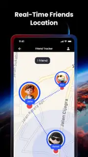
The application implements a coded connection system for location sharing. Users exchange or input unique friend codes to establish a shared tracking session. Once linked, contacts appear as moving icons on the interactive live map, with their position updated in real-time. This system is engineered for logistical coordination during meet-ups or for monitoring family members during commutes and travel, providing a factual overview of whereabouts without reliance on constant messaging.
Interactive 3D Maps and Live Camera Feeds
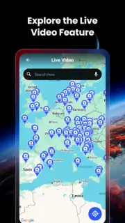
Beyond standard vector maps, the app provides rendered 3D terrain and city models, offering perspective for trip planning and virtual tourism. This is supplemented by access to a network of live public camera feeds from various global locations. The integration allows users to visually verify conditions at a destination—such as weather, traffic, or crowd levels—before arrival, adding a layer of pre-travel reconnaissance.
GPS Navigation and Geotagging Tools
The integrated GPS toolkit provides standard turn-by-turn routing and location search. A distinct feature is the geotagging function, which enables users to pin specific coordinates and attach photos or notes directly to that map point. This creates a personalized, visual log of journeys, useful for documenting travel routes, marking points of interest, or remembering specific locations for future return visits.
Ad-Free Experience and Performance Mode
The application offers a Turbo mode or similar premium tier, which removes all advertising interstitials and banners. This mode typically unlocks enhanced map detail, higher refresh rates for live data, and potentially increased accuracy for the friend tracking feature, resulting in a less interrupted and more performance-oriented user experience.
- Real-time friend location tracking
- Global live camera and satellite views
- Detailed 3D maps and terrain models
- Offline navigation and geotagging
Start navigating with a clearer advantage and enhanced situational awareness today. Download the mobile app now to activate your live tracker.
Heads up: you'll need wifi for most live features like satellite views and camera streams. Some cool stuff like the full ad-free Turbo experience is extra.
Information
| Version | 1.3.5 |
| Developer | DN Solutions |
| Requirements | Android Android + 8.1+ |
| Updated | 17.03.2026 |
| Size | 56.35 MB |
| Package | com.live.earth3d.gps.satellite.map |
| Signature | 75c49ccd0e80440f64bfb03288573a18 |
| Architecture | armeabi-v7a, arm64-v8a |


