

Satfinder: Satellite Director screenshots (7)
Description Satfinder: Satellite Director
The Problem of Satellite Dish Alignment
Manually aligning a satellite dish to achieve a strong, stable signal is a process fraught with guesswork. Traditional methods rely on approximate coordinates and physical compasses, often leading to repeated adjustments, weak signal strength, and missed channels. This is particularly challenging in varied terrains or when dealing with multiple satellites, where precision is non-negotiable for optimal reception.
Comprehensive Technical Analysis of Satfinder: Satellite Director
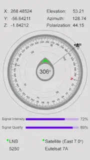
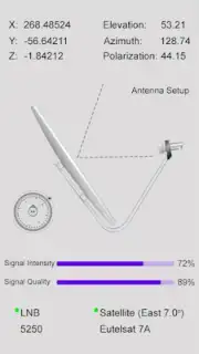
Satfinder: Satellite Director addresses the core technical challenges of dish alignment by functioning as a digital toolkit that replaces estimation with calculated data. The application's primary mechanism uses the device's GPS to determine the user's exact geographical coordinates. It cross-references this location against an integrated database containing the orbital parameters of over 150 communication satellites. From this data, it generates and displays the three critical alignment values in real-time: the precise magnetic azimuth for horizontal direction, the exact elevation angle for vertical tilt, and the correct polarization or skew for the LNB (Low-Noise Block Downconverter). This data foundation transforms the setup from a trial-and-error process into a targeted procedure.
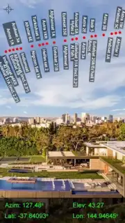
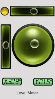
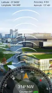
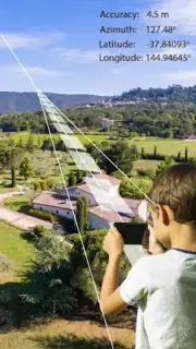
The application implements several specialized tools to act upon this calculated data. The augmented reality (AR) mode utilizes the device's camera and gyroscope to project a live overlay of the sky, with graphical indicators and labels showing the precise real-world positions of satellites. This visual guide allows the user to see the target path directly through their screen, making initial rough alignment significantly faster. For fine-tuning, the application includes a digital inclinometer level for verifying the elevation angle and a calibrated gyrocompass for azimuth. A notable functional detail is the haptic feedback system, which provides a vibration alert when the phone is oriented within the acceptable margin of error for the target satellite's direction, confirming lock-on before any physical adjustment of the dish mount is made.
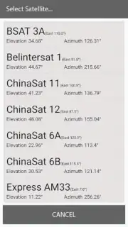
Further utility is found in the satellite view feature, which renders a schematic diagram of satellite positions relative to the user's zenith, aiding in understanding the satellite's arc in the sky for multi-dish setups or future adjustments. For channel planning and verification, the app operates as a frequency and transponder search tool. It provides detailed technical lists for each satellite, including active frequency bands, symbol rates, polarization, and the channels carried on each transponder. This is critical for verifying that a dish is pointed at the correct satellite, not just one with a strong signal, and for troubleshooting specific missing channels.
Core Feature Set
- Real-Time Azimuth & Elevation Calculator
- Augmented Reality Sky Overlay Mode
- Digital Inclinometer and Gyrocompass
- Satellite Transponder Database Search
The interface is designed for utility, presenting complex geospatial data through clear numerical readouts and visual guides. It is optimized for use in both remote areas with clear skies and urban environments where alignment might be obstructed, providing the same level of positional accuracy. The underlying technology ensures that whether performing a new installation or correcting an existing one weakened by weather or movement, the user can achieve peak signal efficiency with a methodical, data-driven approach.
Download Satfinder: Satellite Director now and complete your satellite setup with professional precision on the first attempt!
Disclaimer: This application requires an active internet connection for initial data loading and GPS functionality. Some advanced features or database access may require in-app purchases. The app uses location services and device sensors extensively. Data charges may apply. Use of this tool does not guarantee service from satellite providers and is intended for alignment assistance only. Always ensure safe practices during installation.
Information
| Version | 3.7.0 |
| Developer | Funloft |
| Requirements | Android Android + 5.1+ |
| Updated | 17.03.2026 |
| Size | 12.93 MB |
| Package | com.ar.satfinder.geoareacalculator.inclinometer.quickdishalign.gyrocompass |
| Signature | 061405acf9094f9d0770d5757e47c886 |
| Architecture | armeabi-v7a, x86, arm64-v8a, x86_64 |


